Alaska’s Savage River
Inside Denali National Park and Preserve
By Valerie Winans
A Writer for Readers of All Ages
Chapter Three
Denali: The Town and the National Park

The town is called “the canyon” and is a seasonal place that opens for tourists in May and closes in September. It is the gateway to Denali National Park and Preserve. It is located on the George Parks Highway, between Anchorage in the south and Fairbanks in the north. The Alaska Railroad cut the first path through this canyon, marking the way before the seasonal community or any road ever existed.
The community perches on the edge of a canyon carved out of rock by the Nenana River. The canyon is deep and its walls are steep. The water moves through the narrow spots rapidly, making whitewater visible everywhere on the river as it passes by Denali the town. If you take a switchback road up a mountain on the edge of town you will be rewarded with an awesome view of the town the river one of its bridges, and its valley.
In the summer months, the town’s population consists of visitors and those who serve them. Many employers provide housing for their workers as nearly all of the employees come from all over the United States as well as other nations. Most visitors drive north to the park from Anchorage, where they have just deplaned or come ashore from a cruise ship. Some arrive via the Alaska Railroad, some in rented vehicles, and some hearty individuals drive their own vehicles from destinations around the world.
The town offers beautiful hotels, great restaurants, and specialty shops. Uniquely Alaskan items are available from local artisans, such as carvings, jewelry made from local gems, furs, birch bowls, and much more. Activities include rafting the Nenana River, helicopter rides, fixed-wing flights over Mt. McKinley (now Denali) or landing on a glacier, four-wheeler tours, golfing, and dinner theatre.
Leaving the George Parks Highway to enter the park, the first place you see is Riley Creek Campground. It is the largest campground in the park and the nearest to all services. It is within walking distance of the canyon town of Denali Park and its amenities. If you want a different experience, all of the campgrounds in the park provide a starting point for hiking, wildlife encounters, scenic views, and meeting people from all over the world.
My favorite trail at Riley Creek Campground takes hikers to the base of the railroad bridge, which is where some of the first settlers lived. If you look carefully, you will see remnants of their life along the creek.
Near the Visitor Center at Riley Creek Campground is a trail that leads to the top of Mt. Healy. It is a somewhat strenuous hike, but doable even for the occasional hiker. I would have made it to the top, with bragging rights to the summit of Mt. Healy, but for a grizzly bear that took up residence that day along the trail. People who had reached the summit could not descent due to the bear, and those wanting to reach the top chose to leave rather than have a confrontation with such a formidable foe.
If the town is the gateway to the park, the park road is its passport to adventure. In her thesis, “From Myth to Reality,” Gail Evans describes the road as the place where nature and culture meet.
“In the park’s early history, construction of a winding,
ninety-mile road in a remote, harsh, unforgiving
natural environment, dominated all other
administrative efforts. This herculean effort to
create cultural access to abundant wild nature in
Mount McKinley National Park exemplifies the
transformation of the philosophy of democratic use
by “all the people” into reality.”
This narrow winding road was constructed between 1922 and 1937. During the fifteen years of construction, the Alaska Road Commission worked in partnership with the National Park Service to accomplish this awesome “linear cultural artifact.” Some improvements have been made since that time by widening the road, moving some sections of the road to higher ground, as well as grading and maintenance. It was recognized at the outset that a road into the park would be needed if the public was going to be able to access the wilderness. Several suggestions were made for routes into the park. In 1917, USGS geologist Stephen Capps stated that there should be a road “reaching from the railroad westward to McKinley. (Now Denali) Such a route…has already been provided by nature. A remarkable series of low passes…form a natural highway through this rugged area. For centuries the game herds have used these passes, and deeply worn trails (that) lead from valley to valley along the easiest route.”
Eventually, the road would reach ninety miles into the park and afford panoramic views of Mt. McKinley (Denali). In addition, it offered a way back to the railroad and civilization for the miners and homesteaders living far out in the bush. Visitors have always been driven as far as the road would allow, first in touring cars and later win buses. The road opens a window to the wilderness for many who otherwise would not be able to partake of its beauty.
Railroad connection to the park and improvements made to the road contributed to increased tourism. The seasonal town was established in those early years, and as the “linear cultural artifact” progressed farther into the park, each year it extended the passport for visitors to go from town to park and experience more and more of the awesome natural phenomenon now known simply as Denali.
At the beginning of the season, just prior to the arrival of the first buses in the park, the road is opened to private vehicle traffic as far as Teklanika. What a great opportunity it is to take this road trip, stopping along the way wherever you wish and for as long as you wish. The first view of Mt. McKinley (Denali) is where the park road first approaches Savage River. Closer and more breathtaking views of the mountain are possible from other spots farther along the park road past Teklanika – but that first view of the mountain from Savage is special. With or without a view of the mountain at Savage River, the landscape is spectacular. The rivers are braided here because silt from the glaciers that feed the rivers eventually block the routes of steam causing it to find an area of less resistance and thus the water heads off in another direction. The road from Savage River Campground to Teklanika goes up and down in and above the tree line. The boreal forest is pristine and the views from higher elevations display the green growth of spring, as well as various-colored minerals in the rocks of the mountains. The landscape also offers views of the beautiful rolling Piedmont, with occasional patches of birch, alder, spruce, and willow.
As you travel into the park you might notice huge boulders in the middle of nowhere. They are called erratics. One of Webster’s definitions for erratic is “transported from an original resting place especially by a glacier.” Sure enough, these magnificent rocks, some as big as a two-story house, have been deposited by glaciers.
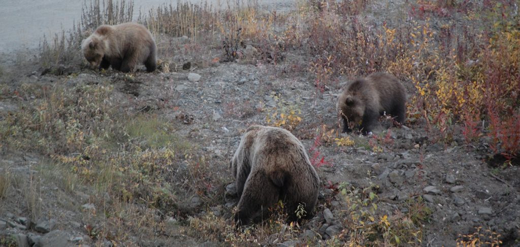
The higher elevations are home to Dall sheep. At the start of the season, you will often see the ewes with their lambs. The bears, not long out of hibernation, are busy eating their favorite spring meal of roots and squirrels. If they can find them, they dine on baby caribou and moose as well. Caribou have been on the move to find summer grazing for some time, but occasional herds are still seen in the valleys. Moose are everywhere, from the visitor center parking lot to the farthest reaches of the park. The grizzly bears, caribou, and moose are a sight, but the birds are just as pleasing.
The ptarmigan change color, from pure white in the winter to multiple brown shades in the summer. This early in the season, they are mostly part white with the brown of their summer adornment beginning to show. The grey jays, ravens, and magpies make their presence known through their raucous calls and high-jinks. The white-crowned sparrows and the yellow-dumped warblers contribute with sweet sounds for balance.


